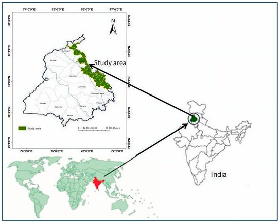
The geography of Punjab, a region in South Asia, is diverse and characterized by its fertile soil, abundant water resources, and significant agricultural productivity. This essay will explore the various aspects of Punjab’s geography, including its soil composition, forests, rivers, and topography. Northern India’s Punjab state (/pndb/ (listen); Punjabi: [pndb]) is a state. The state, which is a part of the larger Punjab region of the Indian subcontinent, is bordered by the Indian union territories of Chandigarh to the east and Jammu and Kashmir to the north, as well as by the Indian states of Himachal Pradesh to the north and northeast, Haryana to the south and southeast, and Rajasthan to the southwest. Punjab, a Pakistani province to the west, shares a common international boundary. The state is the 19th biggest by size out of 28 Indian states (and the 20th largest if Union Territories are taken into account), with a total area of 50,362 square kilometers (19,445 square miles), or 1.53% of the country of India’s total geographical area.
Soil Composition
Punjab’s soil composition is highly suitable for agriculture and contributes to the region’s agricultural prosperity. The soil types found in Punjab include alluvial, loam, sandy loam, and clayey soils. Alluvial soil, deposited by rivers, is the most dominant type and is known for its high fertility and excellent moisture retention capacity. This fertile soil allows for the cultivation of a wide range of crops, including wheat, rice, cotton, sugarcane, and vegetables.
Rivers
Punjab is known as the “Land of Five Rivers” due to the presence of five major rivers: Beas, Chenab, Ravi, Sutlej, and Jhelum. These rivers, originating from the Himalayas, provide a reliable source of water for irrigation and contribute to Punjab’s agricultural productivity. The rivers also serve as important transportation routes and support diverse aquatic ecosystems.
Water Resources
Apart from rivers, Punjab has an extensive canal irrigation system, primarily fed by the Indus River and its tributaries. The canal network, including the Bhakra Canal, Sirhind Canal, and Bist Doab Canal, helps distribute water to farmlands throughout the region. These water resources play a crucial role in sustaining agriculture and ensuring food security in Punjab.
Forests and Wildlife
Punjab’s forest cover is relatively limited compared to its agricultural land. The region has predominantly scrub forests, which consist of trees like Acacia, Neem, and Shisham. The forests also support a variety of wildlife, including deer, antelopes, foxes, jackals, and numerous bird species. Conservation efforts are underway to protect and restore forest ecosystems in Punjab.
Topography
Punjab’s topography is generally flat, with some hilly terrain in the northeast. The Shivalik Hills, an extension of the Himalayas, forms the northeastern boundary of Punjab. The fertile plains, known as the Indo-Gangetic plains, dominate the region, making it ideal for agriculture. The flat topography, combined with the extensive canal system, facilitates efficient irrigation and land use for agricultural purposes.
Climate
Punjab experiences a predominantly continental climate characterized by hot summers and cold winters. Summers are hot and dry, with temperatures often exceeding 40 degrees Celsius (104 degrees Fahrenheit). Winters are cold, with temperatures dropping below freezing point in some areas. The region receives most of its rainfall during the monsoon season, which occurs from July to September.
Land Use
Agriculture is the primary land use in Punjab, covering a significant portion of the region. The fertile plains and abundant water resources support intensive agricultural practices. The major crops cultivated in Punjab include wheat, rice, cotton, sugarcane, maize, and vegetables. In recent years, efforts have been made to diversify land use and promote agroforestry and horticulture.
Urbanization
Punjab has witnessed rapid urbanization, with cities like Ludhiana, Amritsar, Jalandhar, and Chandigarh experiencing significant growth. Urban areas in Punjab are centers of economic activity, trade, education, and administration. As urbanization continues, it poses challenges related to infrastructure development, environmental sustainability, and managing urban growth.
Punjab state (/pndb/ (listen);Punjabi: [pndb]) is a state in northern India. The state, which is a part of the larger Punjab region of the Indian subcontinent, is bordered by the Indian states of Himachal Pradesh to the north and northeast, Haryana to the south and southeast, and Rajasthan to the southwest, as well as the Indian union territories of Chandigarh to the east and Jammu and Kashmir to the north. It has a shared international border with Punjab, a province of Pakistan to the west. With a total area of 50,362 square kilometers (19,445 square miles) or 1.53% of the nation, the state is the 20th largest geographically out of the 28 Indian states (and the 19th largest if Union Territories are included).
In conclusion, Punjab’s geography, with its fertile soil, extensive canal irrigation system, abundant water resources, and favorable topography, contributes to its agricultural productivity and sustains the region’s status as the “Breadbasket of India.” The rivers, forests, and diverse land use patterns shape the environmental and economic dynamics of Punjab. Understanding Punjab’s geography is essential for managing its resources effectively, ensuring sustainable development, and addressing the challenges associated with urbanization and environmental conservation.


